Interactive
Map Paper (Codename: Pirate)
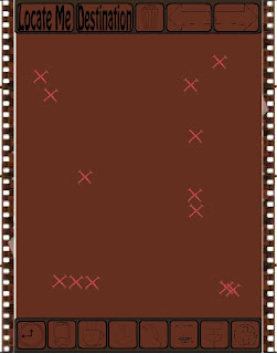
My navigation device is a like a futuristic pirate map where
you are marked by an icon of a person and where X marks the spot where your
destination.
Information is gathered via GPS.
There are quick find buttons on the bottom toolbar that will
locate the nearest locations of places such as toilets, cafés and your next
lecture.
The rubbish bin icon at the top will take you back to the
first screen at any point and the arrows will go back and forwards through
screens you have already navigated.
The main function is to navigate from your current point to
a destination to do this click ‘locate me’ and GPS will track you down.
Using your fingers on the touch screen you can zoom by
placing them on the screen and sliding them away from each other.
To find your destination you need to click the ‘destination’
button. This brings up a qwerty keyboard so you can type in your location. Then
click ‘find’.
The dashed lines show where to walk. Red lines are on your
current level. Blue lines are on levels of buildings that are higher or lower,
the colours automatically update as you go to other levels. At any time you can
scale a building’s levels by putting two fingers on the screen and sliding them
up or down dependant on which floor you wish to view.
Once at your destination the X will flash and then
disappear.
My navigation interface enables the user to know their
direction as the top of the screen always points north, but the person icon
turns depending on which direction the top is pointing.
I wanted to make a futuristic tool that wasn’t merely an
application, because when a tool is its own substance a person will respect it
and look after it better.
 |
| First Screen |
 |
| X Marks the spot of a number of places that match the destinations description, eg. toitlet |
 |
| GPS locates the user |
 |
| QWERTY keyboard pops up when the my destination button is pressed. |
 |
| red dashes show the pathway on your current floor, blue dashes show the pathway on higher or lower floors. |
No comments:
Post a Comment